Semantic segmentation approaches for crop classification with multi-altitude Google Earth imagery
DOI:
https://doi.org/10.62110/sciencein.jist.2024.v12.832Keywords:
Remote sensing, Google Earth Imagery, satellite images, semantic segmentation, U-Net, Deep LearningAbstract
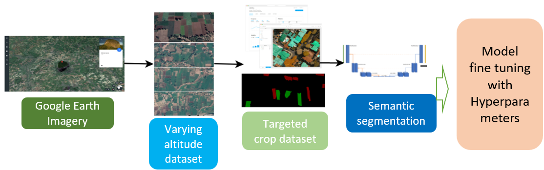
Image Segmentation with Remote Sensing (RS) dataset is highly challenging in many applications, such as agriculture, land classification, and disaster management, due to high interclass similarities in features, noise in the data, and the need for appropriate algorithms for segmentation. Traditional approaches utilize machine learning (ML) and deep learning (DL) algorithms, and they have performed well for this in the availability of many image datasets. Because of the advantages and applications of U-Net architecture for semantic segmentation, even with the scarcity of training image samples, this paper aims to apply pixel-wise classification of aerial images and image segmentation with U-Net and U-Net image blocks. The paper's novelty is to apply segmentation for a single-day varying altitude image dataset collected from a village in Gujarat using the Google Earth’s sentinel satellite image views. The classification has been carried out for two major crops, wheat, and Ricinus. The assessment of various architectural frameworks for the segmentation and classification, including ML, DL, and U-Net, by fine-tuning the models with monotonic learning rate (LR) and Cyclic LR, are included in this paper. The U-Net architecture for a dataset with 500m altitudes with a Validation Accuracy of 94.6%, Loss of 3.48%, Area Under Cover (AUC) of 95.76%, Sensitivity of 99.5%, and Specificity of 99.07% and another U-Net image block ResUNet architecture with Cyclic LR for 1000 m altitude outperform the traditional ML, DL algorithms with Validation Accuracy 98.5%, Loss 0.93%, AUC 88.91%, Sensitivity 92.86%, and Specificity 95.42%. Significantly, the U-Net and its image block architectures with Cyclic LR outperform the ML and DL variants.
Downloads
Downloads
Published
Issue
Section
URN
License
Copyright (c) 2024 Manan Thakkar, Rakeshkumar Vanzara, Ashish Patel

This work is licensed under a Creative Commons Attribution-NonCommercial-NoDerivatives 4.0 International License.
Rights and Permission
How to Cite